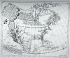
In 1625 respected British mapmaker Henry Briggs published the most detailed map of North America to date. It became one of the most respected New World maps in Europe and helped promote the theory that California was a long narrow island off the west coast of North America. This was in part due to him trusting a map made by Antonio De La Ascension that he trusted to be true. It was soon contested by explorers to the region, and by the early 1700's it was proven to be wrong. The island theory still lasted well into the 1700's before the king of spain, King Ferinand VII decreed that California was an island.
Attachments
-
 106.4 KB Views: 3